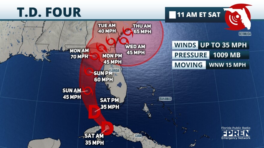
The system we have been monitoring gained a bit of strength and became a tropical depression late last night. Tropical Depression 4 will emerge over the Florida Straits on Saturday and travel over the very warm waters of the Gulf of Mexico. The track has shifted westward, with a more pronounced curve which keeps it over the warm waters a bit longer and gives it more time to become stronger. It also delayed its landfall, and it is now expected to make landfall early on Monday morning in the Big Bend region, as a strong tropical storm or category 1 hurricane. A hurricane watch is in effect for the Big Bend. This means hurricane conditions will start within the next 48 hours. A tropical storm warning is in effect from Southwest Florida through the Tampa Bay area to Inglis.

We are closely monitoring the speed of the system as it is showing signs of slowing as it approaches the Big Bend on Monday. The speed on Saturday will stay steady but expect a gradual slowdown on Sunday and Monday, which will bring more frequent rounds of rain and storms over already saturated areas across north and central Florida from Sunday through Tuesday. By Wednesday morning, the system could reemerge over water, this time in the eastern Atlantic by the South Carolina Coast. It is likely to continue hugging the coast through Thursday, with its center over water, which means that it could gain strength and is likely to become a hurricane. Water temperatures near the coast of the Carolinas are warm, between 82 and 86 degrees. This serves as prime fuel for this system to gain strength, and likely gain it quickly.
What can Florida expect?

Storm surge could be 3 to 5 feet, mainly in spots along the Big Bend. In the west central coast, including the Tampa Bay area storm surge could range between 2 and 4 feet, and in the southwest part of Florida between 1 and 3 feet.
This is still a soaker of a storm for Florida. Across South Florida, the last 24 hours have brought between 1 to 1.5 inches of rain across the Greater Miami region while some spots south of Naples have received 2 inches of isolated rain. More rainbands are moving from southeast to northwest on Saturday as the system gets ready to exit Cuba. Expect the rainbands to continue to move northward and reach Central Florida by noon and in the middle of the afternoon the first rainbands should be reaching North Florida. As the system moves over the Gulf of Mexico the rain bands will move from south to north then west to east as it makes the turn toward Florida.

Rainbands could drop high rainfall in a short amount of time, and there will be several of those so there is a high risk for flash flooding. Rivers and lake levels will be quickly rising and could flood rapidly too. The highest rainfall is still expected over the west coast of Florida, from the southwest region through the Tampa Bay area, Big Bend, east of Tallahassee, and Jacksonville. There could be some spots that could have 10 inches of rain. This is a large system so once the rain arrives in the northern portion of Central Florida and North Florida you can bet for it to continue through early next week. Please avoid all flooded roads. Remember to turn around, don’t drown.
Another important aspect of the rainbands is that they can bring gusty winds (at least 60 mph) as there will be some embedded storms within the rainbands. There could also be some rotation within the storms that could produce tornadoes. Please remain indoors, these tornadoes tend to form quick spin-ups and they can be dangerous and cause damage.

We will bring you updates here. You can expect a new story containing the latest information with each full bulletin issued by the National Hurricane Center at 11 a.m. and 5 p.m. and in between we will have updates on the latest story with any crucial information. Our team of meteorologists will also bring you updates on your local Public Radio station.

