
-
 Multiple rounds of potentially severe thunderstorms are possible over Florida's Panhandle and North Florida Thursday afternoon through Friday night. Interests in these areas should continue to seek forecast updates, and are urged to heed any warnings issued for their location.
 -
 Angelos Tzortzinis/AFP via Getty ImagesEl Niño helped drive global average temperatures to new records over the last year. Forecasters say it's waning, but that 2024 may still be one for the record books.


-
 Floridians may not be wearing mittens and scarfs this Christmas. A frontal system moving through will increase chances for showers and thunderstorms on Sunday and Monday for much of the state.
 -
 Strong winds and 3-5 inches of rainfall are possible across most of the state this weekend. Before the main storm arrives, conditions to remain windy on Friday.
 -
 Weather patterns are changing entering the winter season, and this could continue to bring wetter conditions to the Southeast.
 -
 The 2023 Atlantic Hurricane Season officially comes to an end today, concluding six months of above-normal activity.
 -
 A frontal boundary will slowly track through the Florida Panhandle starting late tonight. Abundant moisture will increase ahead of the system causing rounds of heavy rain and isolated severe storms Friday through Sunday.
 -
 A rise in rain totals is expected for tomorrow for much of the sunshine state.
 -
 Scattered storms will impact parts of the state through Wednesday. Cooler and partly to mostly cloudy for the northern half of the state on Thanksgiving.
 -
 A Gulf Low and a Caribbean system will simultaneously impact Florida this week. Flooding winds and damaging wind gusts are expected over the Panhandle and South Florida
 -
 One in four people, or 1.9 billion, experienced a five-day heat wave, at minimum, influenced by carbon pollution.
 -
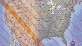 An annual solar eclipse will be visible over North America this weekend. Here is what you need to know.


