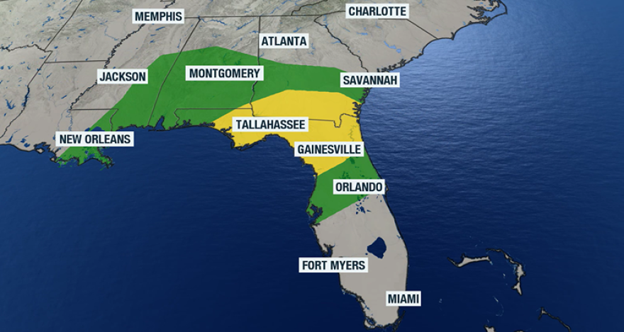
At least one round of showers and thunderstorms is expected to sweep across Florida on Sunday, bringing the risk of isolated strong to severe storms as the system moves from west to east across the state.
In the stronger storms, damaging wind gusts will be the primary concern, but a brief tornado cannot be ruled out, especially across northern Florida, including parts of the Panhandle.
The Storm Prediction Center has placed portions of the region under a Slight Risk, or Level 2 out of 5, for damaging storms on its severe weather scale. This designation means that scattered severe storms are possible, but they are not guaranteed.
Areas included in the risk zone could see storms capable of producing damaging wind gusts and an isolated tornado, particularly during the late morning and afternoon hours when atmospheric conditions are more favorable for development.
According to historical data, February is typically one of the quieter months for severe weather across the Sunshine State, with a slight uptick in reports during the spring.
In addition to the possible severe weather, heavy rainfall and frequent lightning will accompany the storms, which can always be dangerous.
Temperatures climbing into the 70s and near 80 degrees, combined with available moisture, will help produce needed elements for the storms, but how much instability will be present remains uncertain.
Sea surface temperatures along parts of the coastline remain relatively cool, which could help limit the overall ingredients for some of the storms.

The timeline for the greatest chance of precipitation is expected to be between 9 a.m. and 2 p.m. across the Florida Panhandle.
Farther east and south across the peninsula, the highest rain chances are forecast between 1 p.m. and 10 p.m.
As the entire storm system continues moving eastward, cells are expected to gradually weaken after sunset.
As a result of weakening and dry air around, communities across the southern portion of the state are likely to see lower rainfall totals and a reduced severe weather threat compared to areas farther north.
Among the locations included in the rain chances is Daytona Beach, home to NASCAR’s annual Daytona 500.
Race officials say that any amount of rainfall on the 2.5-mile track results in delays due to the hazards posed to cars traveling at speeds around 200 mph.
To combat the rainfall, the Daytona International Speedway is equipped with drying systems designed to accelerate the process of clearing water from the track. Depending on the duration of rainfall, drying the course can take anywhere from 90 minutes to several hours.
Even outside of the thunderstorms, winds are expected to be breezy, with gusts upward of 30 mph ahead of the front.

Despite the potential for impacts on Sunday, rainfall will be welcome news across the state.
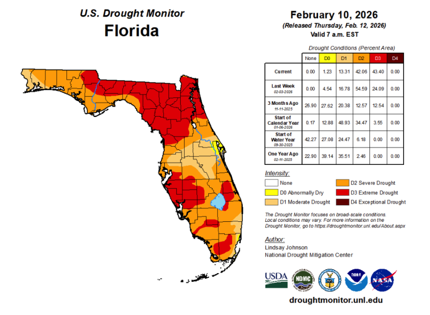
Nearly all of Florida is experiencing some level of drought conditions, with a significant portion of the state facing extreme drought - levels not seen since the early 2000s.
Drier weather is forecast to return to much of the state Monday and continue through the upcoming workweek.
An area of high pressure building over Florida and the Gulf Coast will be responsible for warmer and drier air, with widespread temperatures in the 70s and 80s during the week.


