

Florida will enjoy cool weather throughout the rest of this workweek, which is also spring break for many. Highs on Tuesday struggled to reach the mid-50s across the Panhandle, even with sunshine, and had difficulty reaching the low 60s across Central Florida as clouds lingered along the southern fringe of the region.

Many locations across Central Florida have remained much cooler than average for this time of year. In fact, along the I-4 corridor, several cities and towns could come close to setting record cool maximum temperatures for the day. Daytona Beach is forecast to reach 57°F, while the record set in 1962 is 59°. If the temperature stays below 59°, this would mark the coolest March 17 afternoon in over 60 years.
Freeze warnings are in effect
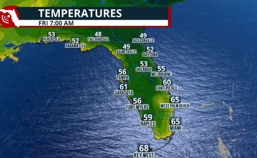
Tuesday night will be the coldest night across much of Florida. The Panhandle and North Florida are under a freeze warning through Wednesday morning. Temperatures will drop to the upper 20s to low 30s, and there could be widespread frost, especially across areas between Gainesville and the I-95 corridor.


Make sure to protect people, pets, plants, and pipes.
Across Central Florida, temperatures will fall to the low to mid-40s with a few clouds in the sky. For South Florida, this will be the coldest night of the week, with lows in the mid to upper 50s under mostly cloudy skies. There is also a chance for passing showers in the evening, which will likely taper off between midnight and 5 AM. Keep in mind that rain chances will continue across South Florida as the trough slowly moves east and will take another 24 hours to clear. We expect a clear morning by Thursday, with only a few clouds in the afternoon.
Temperatures across the Sunshine State will increase through the rest of the week. Nonetheless, expect readings to remain below average by 2 to 5 degrees in the afternoons on Thursday and slightly below average again on Friday.

A preview for the weekend
Afternoon temperatures will return to near-average or slightly above-average by Saturday across the northern half of the peninsula. The same high-pressure system that has brought record heat to the Southwest will slowly migrate eastward. We do not expect this system, or ridge of high pressure, to be as strong as it moves east, but parts of the Panhandle could see temperatures 5 to 10 degrees above average for this time of year starting Saturday afternoon and continuing through the weekend into early next week.


Across South Florida, temperatures will remain slightly below average through Sunday morning, although afternoon highs will rebound into the 80s by Sunday.
🏖️Spring Break is right around the corner! Are you planning a beach trip?
— NWS Tampa Bay (@NWSTampaBay) March 4, 2026
🌊Tides, winds, and waves can lead to dangerous conditions and impact your plans at the beach.
🔎Be sure to check the Beach Forecast before you head out. pic.twitter.com/LDjWoPP0iB