

While over 160 million people are at risk of experiencing a historic winter storm this weekend, which will bring a thick ice layer, for many, heavy snow for many states stretching from Texas through the Northeast, Florida will just experience a cooldown early next week, but will not be as frigid as the one experienced last week. Florida will be a brief and minor participant in this round of winter, moving across the nation.
THE SCIENCE BEHIND THE POLAR VORTEX
The arctic air will remain focused across the Plains, then shift to the Northeast throughout the week. Some cold air will filter south over Florida, and although it will linger through much of the week, allowing temperatures to remain below average, the coldest temperatures will just last one day, Tuesday, followed by a slow increase.
Before the cold weather arrives, temperatures will be toasty to end the week and more for the weekend. Temperatures across the Sunshine State this weekend will be the warmest in the entire lower 48 states. Highs on Saturday will be in the low 80s across Central and South Florida, while North Florida and the Panhandle will be between the upper 60s and low 70s.
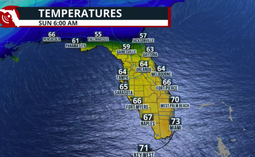
Sunday morning will be significantly warm and muggy. The winds will be from the south, including straight from the Gulf, which will keep the temperatures around sunrise in the upper 50s. This is close to 20 degrees above average for this time of the year across the Panhandle.

There is a chance of severe storms in Florida as the front approaches.
As is common, the fronts that bring such drastic changes in temperature and are well-pumped with moisture also bring a chance of severe storms. The moisture is what we have been lacking with the many fronts that have crossed Florida. But this one, as you know, will cause all kinds of precipitations for our friends up north. Florida will remain with liquid precipitation, but storms that develop could be strong to severe along the Panhandle between Sunday afternoon and Sunday. The biggest risk will be of strong, damaging gusts and the possibility of a tornado or two. We will continue to monitor this and bring you an update on Saturday. Please stay tuned.


Next week, temperatures will drop. The coldest day overall for the entire state will be Tuesday, with the Panhandle waking up to lows in the upper 20s and windy. South Florida will be in the low to mid-50s and on a slow but steady upslope for the rest of the week.

