

A high-pressure system in the upper levels of the atmosphere will set up camp near Florida, causing air to sink. This sinking air will warm as it approaches the ground. In combination with winds mainly out of the east-southeast near the surface, this will bring toasty temperatures throughout the weekend.
The ingredients will be in place for temperatures to approach records this weekend across many parts of Florida. Temperatures are already starting to creep up as we head closer to the weekend. The highest temperatures are expected to be mainly focused across North Florida, Central Florida, and the West Coast of the state.
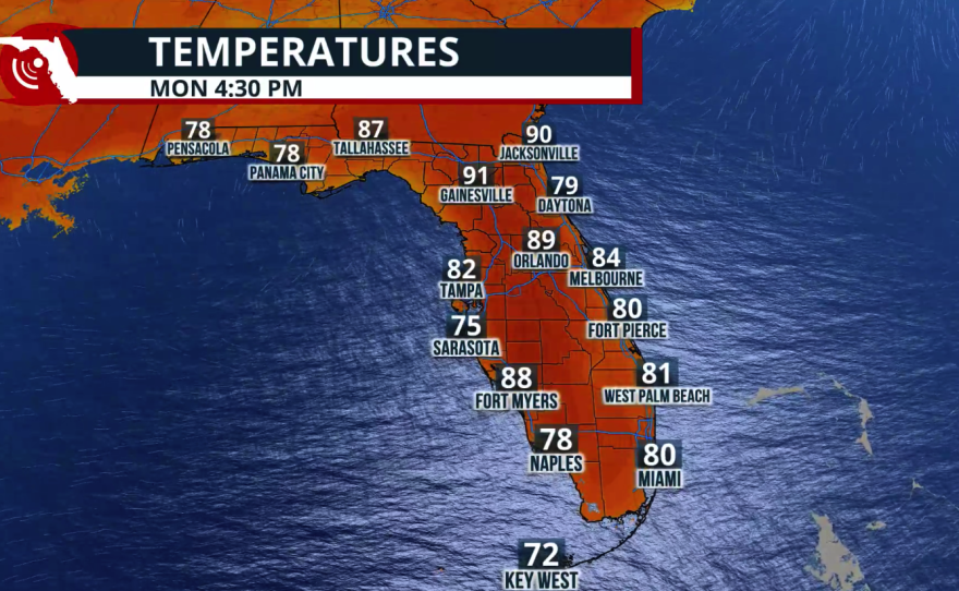
This will be due to the east-southeast winds. While these winds will still bring warmer-than-average temperatures to the East Coast, those areas will be slightly cooler compared to the western half of the peninsula. Remember that as air travels over land, it warms. Therefore, the warmest temperatures will likely be recorded between Gainesville and the I-4 corridor, and by Monday, places as far south as Punta Gorda could see temperatures near 90°F.


Although the weekend will be marked by near-record or record-breaking warmth, most records will likely be tied or broken in the afternoon. Saturday morning could also come close to a record warm low in Orlando. The record warm low for the day is 68°F, established in 1973, and we are likely to stay close to this value.
These temperatures are more in line with the average highs typically seen in May, especially toward the end of the month.
As for record highs, areas between Lakeland and Tampa Bay could reach the upper 80s. Along the I-4 corridor from Sanford through Tampa, including Leesburg, temperatures could also approach 90°F on Saturday and Sunday afternoon. The warmth is expected to persist and may even expand for the first half of next week. Temperatures are forecast to remain between 86°F and 89°F. Humidity will also be present, which means temperatures could feel as high as 95°F.
Drought Update
The good news is that no area in Florida has moved into a higher drought category. Most of the state held steady in the same categories as last week. The only region that worsened was Southwest Florida, which is now in extreme drought.
Keep in mind that this week we have experienced east-southeasterly winds that have kept moisture streaming across the Sunshine State, helping to develop showers. Most of these showers have fallen during the overnight hours across South Florida and interior areas.


If this same flow continues and brings the steady showers we have recently been receiving, some areas could slowly begin to see improvements in their drought categories. However, the warmer temperatures we will experience could also influence drought conditions by keeping them in place or slowing improvement.
Risk of Rip Currents
The easterly winds will continue to bring a risk of rip currents along Florida’s East Coast. If you are planning to head to the beach anywhere along the East Coast of Florida, the weather will remain mostly stable, but keep in mind that the seas could be dangerous. Rip currents are silent killers, and it is important to know how to identify them and what to do if you encounter one. Be on the lookout for flags warning of their presence. It's best to stay out of the water when not sure or swim near a lifeguard.
Read more about rip current safety here.